St Kilda walk – Photo supplied by Donaldytong
| Start/Finish | Category | Distance | Estimated Walking Time |
| Melbourne Sports and Aquatic Centre / Acland St, St Kilda | Tourism | 4.0 km | 1 hr * |
Summary
Starting at Albert Park this walk winds through the suburb of Middle Park before connecting up to the St Kilda foreshore beach walk. The walk ends on Acland St, which is in the heart of St Kilda.
Public transport
Catch the tram to the Melbourne Aquatic Centre.
Directions
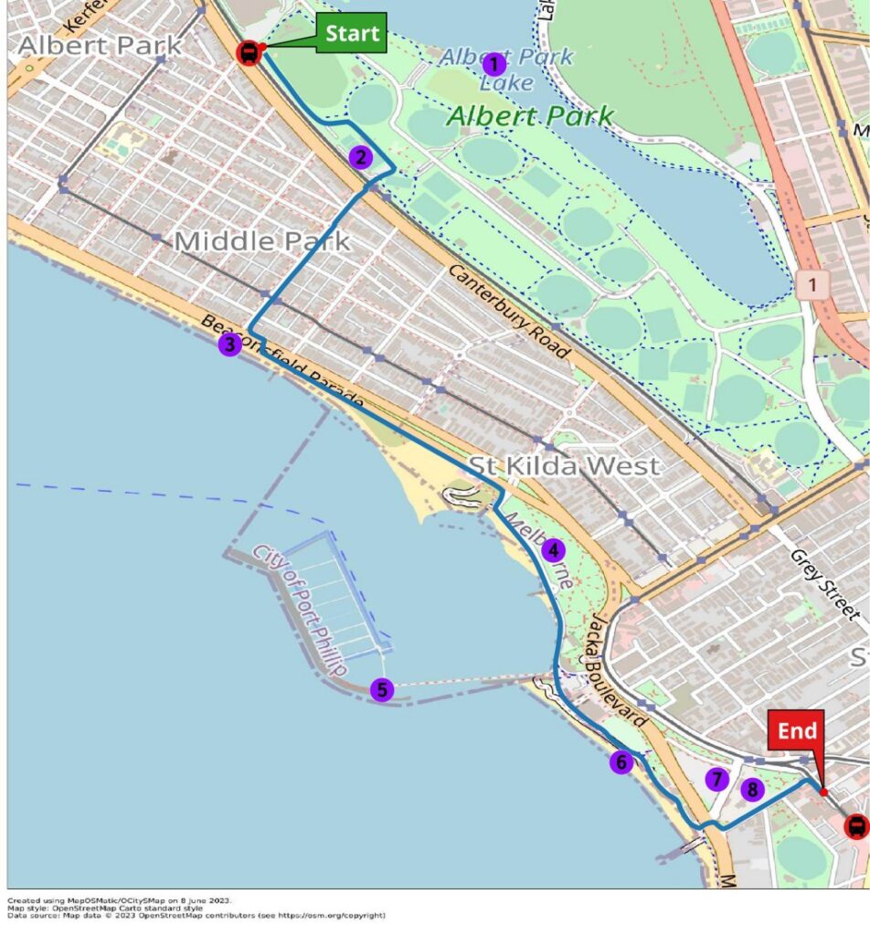
Starting point – Aquatic Centre tram stop
The St Kilda walk starts at the south end of the Melbourne Sports and Aquatic Centre, just opposite the Aquatic Centre tram stop. From the tram stop walk towards the golf driving range and find the Western Bike Path. Walk along the bike path in a south easterly direction.
Along the bike path you will pass the Middle Park Bowls Club. At the back of the club turn right and head southwest to the Middle Park tram stop. Walk past the tram stop and cross over Canterbury Rd. Walk down Armstrong St heading in a southwesterly direction.
At the end of Armstrong St is Middle Park Beach. Turn left down Beaconsfield Pde, which runs adjacent to the beach, and then cross the road at the traffic lights. The walk then continues along the coastal path which runs adjacent to Beaconsfield Rd heading in a southeasterly direction.
This path will connect to the St Kilda beach walk, which departs Beaconsfield Rd and follows the coast along Pier Rd. Along the beach walk you will pass Catani Gardens, which is named after its Italian designer Carlo Catani. The park is lined with Canary Island palm trees and is dotted with a number of monuments. There is also the Melbourne solar system trail along the path, which includes sculptures of all the planets, each one accurately spaced and scaled to give you insight into the magnitude of our solar system.
Catani Gardens
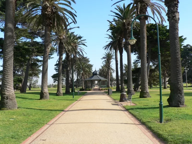
Image: Catani Gardens St Kilda, Photo supplied
Keep walking south and you will pass the St Kilda pier at St Kilda beach. The pier is home to a colony of little penguins and the St Kilda Pavilion at the end of the pier. The pier was first built in 1853 and is a favorite destination for visitors to the St Kilda foreshore.
Continue along the St Kilda beach bay trail and you will pass St Kilda Life Saving Club and then Donovan’s restaurant. Turn left here and cross Jacka Blvd at the lights. On the other side of the road cross Cavell St, which will take you to the Little Penguins Monument.
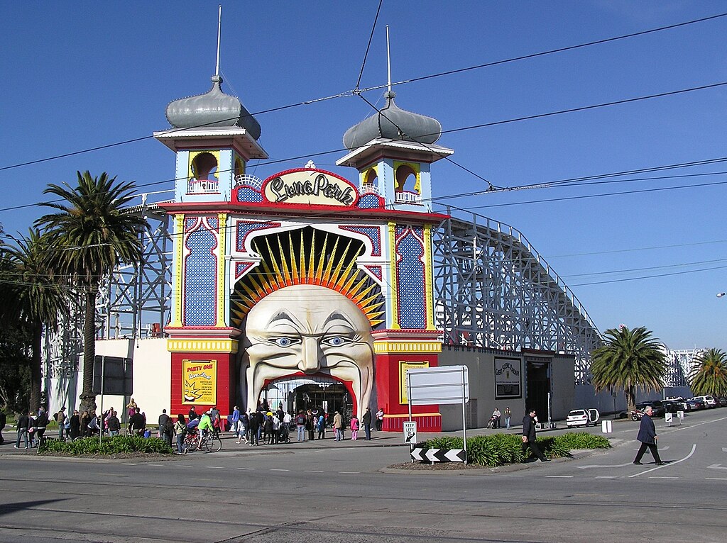
Cross over the road and turn left down Shakespeare Gove. Walk down Shakespeare Grove heading in a northeasterly direction. To your left is Luna Park, a historic amusement park that opened in 1912. The main historic features of the park is its iconic “Mr Moon” face entry and Scenic Railway, which is the oldest continuously operating roller coaster in the world.
Finish – Acland St
Continuing down Shakespeare Grove and you will pass the community gardens before turning right into Acland St where the walk ends.
Acland St is considered to be the central hub of St Kilda and is famous for its range of patisseries and restaurants. No visit to Acland st is complete without trying a cake and grabbing a famous Melbourne coffee.
To get home you can catch a tram back to the city from the Acland St tram terminal.
St Kilda walk – GPX file
To access to the GPX file for this walk click on the download button below.
Information on GPX files and how to import them into Google maps on your phone can be found here.
St Kilda walk- Map
Start – Melbourne Sports and Aquatic Centre
- Albert Park
- Middle Park Bowling Club
- Middle Park Beach
- Catani Gardens
- St Kilda Pier
- St Kilda Beach
- Palais Theatre
- Luna Park
Finish – St Kilda (Acland St)