Adelaide walk – Photo supplied
.jpg)
| Start/Finish | Category | Distance | Estimated Walking Time |
| Elder Park / Parliament House | History and Architecture, Tourism | 5.4 km | 1 hr 20 min* |
Summary
A walk through Adelaide’s city centre, including its central shopping precinct and several other locations of cultural, historical and architectural importance.
Public transport
To get there catch the train to Adelaide Railway Station, or bus to city.
Directions
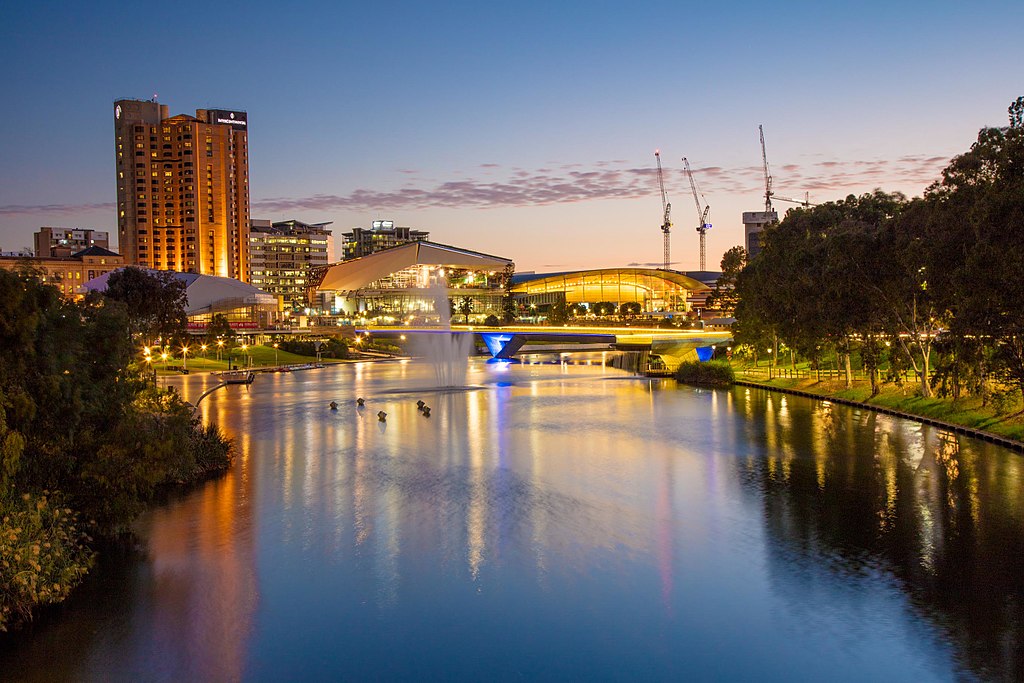
Starting point – River Torrens
The Adelaide walk begins near the Torrens river footbridge just outside the Adelaide Festival Centre. The Festival Centre was Australia’s first capital city multipurpose arts centre. You can access the river by walking to the northern end of Adelaide railway station.
From the starting point, walk along the river bank and head towards Elder Park, which is located between the city and North Adelaide. The park is host to a number of community events such as Carols by Candlelight, New Year’s Eve, OZ Asia Moon Lantern Festival and the Adelaide Festival.
Continue along the river path, under King William Road bridge, until you reach the university footbridge. From here, walk across Victoria Drive and into Adelaide University. Adelaide University was established in 1874 and is Australia’s third oldest university.
Walk through the university before turning right onto North Tce, past the Art Gallery of South Australia, the South Australian Museum and the State Library of South Australia. All three buildings are worth a visit if you have the time. The South Australian Museum is free to enter and has one of the worlds largest collection of Australian indigenous artefacts.
Art Gallery of South Australia

Image: Art Galley of South Australia, photo supplied by Cookaa
At the corner of North Tce and Kintore Ave turn left into Gawler Place and then into Rundle Mall, the heart of shopping, dining and entertainment in Adelaide.
Walk to the Rundle Mall Fountain and then turn into Adelaide Arcade, a heritage shopping precinct in South Australia, which exits onto Grenfell St.
Walk along Grenfell St in a westerly direction and then turn left onto King William St past the Adelaide Town Hall. The Town Hall is famous for its appearance by the Beatles in 1964, which attracted 300,000 fans, their biggest ever crowd.
From King William St, walk around Victoria Square and then turn right into Grote St. Grote St is the home of the Adelaide Central Market and located next to Chinatown. The Adelaide Central Market, which opened in 1869 is a major fresh produce market in Adelaide and well worth a visit if you feel like something to eat or drink.
From Grote St turn right into Morphett St, past light square, and then left down Hindley St. From Hindley St turn right onto Gray St. This will take you back to North Tce.
On North Tce you will notice the distinctive South Australian Health and Medical Research Institute (SAHMRI) building. The SAHMRI building was opened in 2013 and has won several awards for its distinctive and unique design.
SAHMRI building
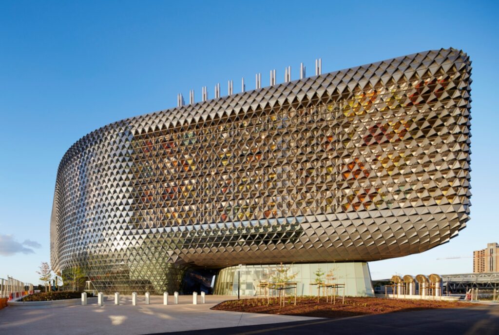
Image: SAHMRI building, photo supplied by Jackstarshaker
From the SAHMRI building walk along North Tce in an easterly direction back towards the Adelaide Railway Station.
Finish – South Australian Parliament
The walk ends at Parliament House, which is located near Adelaide Railway Station and the Casino on North Tce.
Adelaide walk – GPX file
To access to the GPX file for this walk click on the download button below.
Information on GPX files and how to import them into Google maps on your phone can be found here.
Adelaide walk – Map
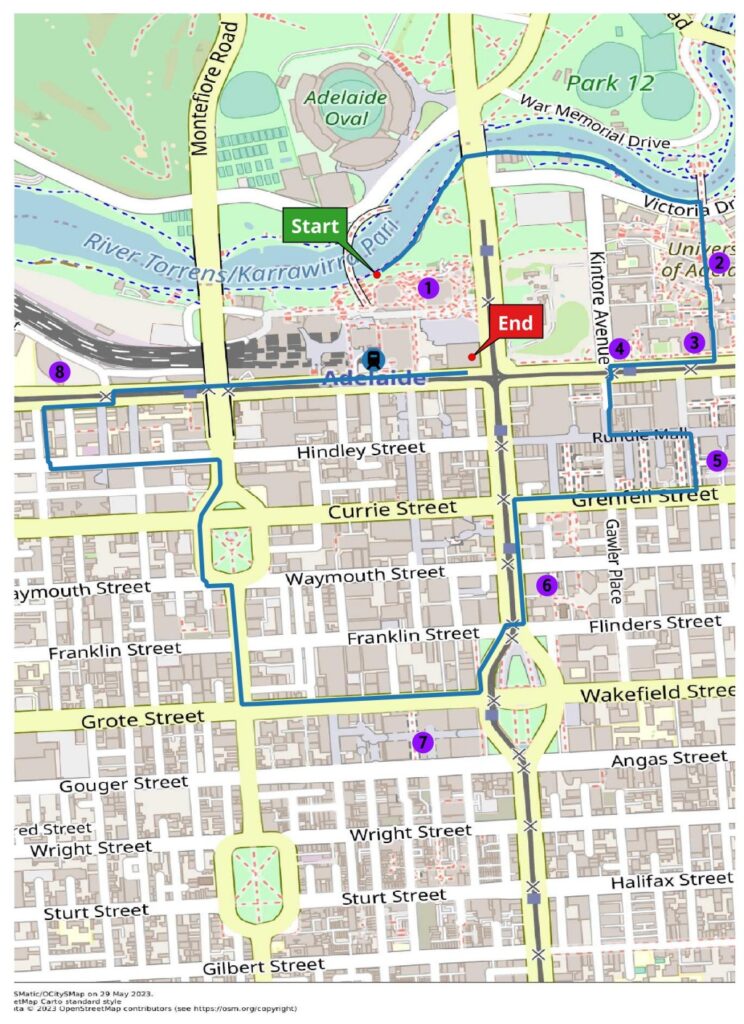
Start – Elder Park
- Adelaide Festival Centre
- Adelaide University
- Art Gallery of South Australia
- State Library of South Australia
- Adelaide Arcade
- Adelaide Town Hall
- Adelaide Central Market/Chinatown
- South Australia Health and Medical Research Institute
Finish – Parliament House